Needless to say, the next morning we slept in. After going to bed at 5:30 a.m. waking up at 11:30 a.m. seemed like torture. Even as tired as we were, we still knew that we were wasting the day by sleeping and forced ourselves out of CJ to face the world. During the night we had drove a significant stretch of the Columbia River Gorge which we were interested in seeing during the daylight. Particularly, our goal was to

venture back to Multnomah Falls, before heading south into central Oregon. Multnomah Falls was one of the most highly recommended stops in the Portland area from Sarah, and since she had never steered us wrong before, we figured we had to check it out. We arrived right about noon and even though it was a weekday, the parking lot was nearly full. First we visited the visitor center and got some information about the Columbia River Gorge which we would have utilized if we had more time to spend in the area. As it was, the falls were our main focus for the day. We walked up to the base then to the bridge which was about half way up the falls. There was also a trail to the top of the falls but we figured that the best views were from down where we already were, so we chose not to hike to the top. After the falls we drove back to Hood River and decided to eat lunch at Full Sail Brewery. We had heard of this place from Scott, our host from Anchorage. It is an independent brewery and is owned by its 47 employees, one of which is Scott's friend. We ate outside on the porch which overlooked the Columbia River and offered a

spectacular view of the gorge as well as numerous wind and kite surfers from which the brewery got its name. We enjoyed this setting as we both ate a delicious pulled pork sandwich before we headed south. We drove for a few hours, racing against daylight to make it down near Bend where we had planned to visit the Lava Fields outside of Sisters Oregon. We arrived just before dusk with enough time to drive through the lava fields, but not enough time to do any of the hikes that we had hoped to do. The lava fields are huge, something like 65 square miles of lava flow. As you emerge from Deschutes forest the landscape changes drastically into a barren wasteland of black rock with nothing to obscure this desert except for the mountains in the background

which generated the lava flow years ago. We reached the Dee Wright Observatory, which was to be our only stop in this impressive landscape, right as the sun was setting. The observatory is an interesting place. It was built by the CCC during the great depression and looks like some relic out of medieval Europe plopped right in the middle of these fields. We climbed to the top and enjoyed the views from within the tower; little windows that perfectly framed the panorama of surrounding mountains. On top of the tower, as the sun set, we were distinctly reminded of how freezing cold it was. Though it was hot during the day, the lava rocks retain no heat and the desert which they created allowed strong winds to pass over the fields. After a few moments of reflection, Katie and I booked it to the car where we blasted the heat and tried to shake off our chill. In a further attempt to heat our insides, we stopped off at Deschutes Brewery's public house where we ate dinner while watching Monday Night Football. After dinner, the chill completely gone from our bodies, we took off down the road for a few more hours finally stopping 30 miles outside of Crater Lake National Park which would be tomorrows destination.
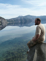
We arrived to Crater Lake in the early afternoon the next day. We still hadn't completely caught up on our beauty rest and thus unwillingly slept in. When we pulled into the National Park we stopped at the first outlook we could find. The view of the lake was stunning. I found it odd to be perched above the entire lake with no visible access to the water itself. Not to

mention that all the water in the lake was from precipitation, no rivers flowing in or out, now thats a weird thing to behold. Because of the high caldera forming the rim of the lake there is relatively little wind which reaches the water level giving the deep blue water a glass like surface for most of the day. After our initial awe of the lake subsided, we made our way to the visitor center to find out about some day hikes. We found 2 that were perfect for us. Both hikes were labeled moderately strenuous, 3 miles long, and offered completely different perspectives of the park. Our first hike climbed to a fire lookout on one of the highest peaks in the caldera, our second plummeted down to the water level deep within the crater. We reached the top of the

first hike without any difficulty. From this vantage point the lake didn't look all that much different than it had at the lookout below, what was special about this hike was the panoramic views. Everywhere you looked you could see the volcanic mountains of the ring of fire stretching out into the distance. We enjoyed the scenery for a bit, though we weren't smart enough to bring lunch up like the hikers just in front of us, then began our decent. On the way down, Katie suggested that I should run to the bottom this path. During our 12 mile hike to visit a glacier back in Glacier National Park, we were passed on the way down by two girls running down the mountain. Ever since then I have had the urge to do this myself but had not yet done it. On this occasion, with Katie's prompting, I decided to give it a go. I ran down the 1.5 mile trail at more of a sprint than I would have liked, the mountain was so steep in parts that it was all I could do to stay on my feet. Every 20 yards or so, especially near the top, there were switchbacks, requiring me slow down to almost a stop, do a 180 degree turn, then carry on. The hardest part came at the last stretch of the trail which follows the old Rim Road at a very mild angle. I tried to keep up my speed at this part causing me to actually put some effort into my sprint and by the time I reached the bottom my face was dripping sweat. Just at this point I passed some older folks who were planning on making the accent. I don't think they noticed me running down the mountain as the path is hidden from the parking lot for most of the hike. They all had a nervous looks on their face because of my current state, huffing and puffing while dripping sweat. I assured them many times that the hike wasn't too bad and that the views were worth it, then watched them march to the trailhead with heavy hearts. Katie came down a few minutes later and we hopped in CJ and headed to our next trail. This trail, as I've said before, was basically the inverse of the trail we had just completed. We started on the crater rim again only this time headed down to the waters edge. At the bottom there wasn't much to do besides sit on the
waters edge and enjoy the stillness of the water. During the summer months there is a boat cruise that takes you around the lake which I am sure detracts from the natural beauty of the place. As it was, we had the place virtually to ourselves, only running into a few other couples who had made the hike down. We sat on some rocks that hung over the water and threw stones in the water creating the only ripples for miles. After about a half our or so we headed back up the trail, stopping a few times on the steep hike up for Katie to regain her composure. After our two hikes we were both ready for some time relaxing in CJ, however we still had to complete the rest of our drive around the crater rim as well as make a few more stops. Next on our list was a visit to the pinnacles, fumaroles that were created during the lava flow from the eruption of

the mountain which formed Crater Lake. They are exactly what you would picture, looking like a miniature Bryce Canyon without such an impressive array of colors. We walked along the edge of the canyon for a while before we reached the parks boundary and turned around. Originally we had planned one more short hike to complete our Crater Lake experience, but by this time we were both done hiking. We made one more stop to view the Phantom Ship, one of two islands in Crater Lake, then hit the road heading

for Ashland, OR, tonight's destination. Along the way we ran into a suggested stop from one of our books and just had to pull over. This was the natural bridge of the Rogue River, formed by a lava tube with the river flowed in and out of. There was a couple interpretive trails that we took along the rivers edge before leaving the area. Though the lava

tubes, canyons, and waterfalls were all really beautiful, we had honestly seen better and since we were both tired of hiking for the day, we didn't stay long. We hopped in CJ and took to the road, heading for Ashland. The drive was mostly uneventful, just listening to Harry Potter while watching the light fade as the sun set before us, until we began to hear loud thumping noises. They sounded like giant bugs hitting the windshield but at first we couldn't see them and didn't know what to make of it. Then all of a sudden it was like we ran into Moses 8th plague, giant winged bugs were hurling themselves at CJ. Katie said that it reminded her of those videos of Asian Carp that hopped out of the water and flung themselves at boats. This phenomena lasted for about 15 minutes but left an impression on our car that can still be seen today. We still have no idea why that particular stretch of road had so many of these things, but it truly was amazing to behold. After the excitement we pulled into Ashland and enjoyed a late but well deserved dinner at Standing Stone then headed to our rest area for the night.
How did you like the beer at Deschutes?
ReplyDeleteIt was really good! They had a lot of very seasonal beer that was really unique to each season and it looked like they do a lot of batch brews. My favorite was called "hop run" which is made from hops that someone drove to pick up fresh from the vine and threw them into the beer as soon as possible. Definitely recommended!
ReplyDelete