
down the road we crossed the Snake River Canyon for the first time. This was a big deal for me and Katie because we both vividly remember crossing this river as one of the last obstacles before completing the computer game Oregon Trail. We got out at the canyon crossing and read about the real Oregon and California trailer's who passed by this spot on their way to make their fortune, while soaking in the beautiful canyon the entire time. A few miles down the road and we made it to our first waterfall stop of the trip, Shoshone Falls, the Niagra of the West. It really was an impressive waterfall, roughly the same height as Niagra Falls and had a similar horseshoe

shape to it. When we first read about the Shoshone Falls, our book only mentioned it as a footnote. Basically saying if we were going to be in the area for the other falls, which they recommended, we should stop in and take a look at Shoshone as well. So when we pulled into the canyon and the massive waterfall came into full view, we were both a little taken aback by its size and beauty. We stayed around the falls for about 20 minutes, walking to the various viewpoints and just watching the water fall in its unending cascade to the river below. From here we headed back to the main road, a scenic byway in Idaho, named for the Thousand Springs Waterfalls which were the falls our book recommended and one of the principle stops on our trip. Along the scenic byway we saw signs for balanced rock, a rock formation that was 20 miles off the road. This site was also on our atlas, so we decided to see what it was all about, figuring 20 miles was a short distance compared to what we had already driven to get here. Balanced rock turned out to be pretty awesome. Along the way we passed miles and miles of potato farms, many of which were in the process of being harvested using massive trucks that dug them up and spit them out into another truck that collected them, somewhat like a moving wood chipper. From this farmland, we suddenly sank down into a canyon valley that had rock

formations much like those you think of when the names Bryce and Zion Canyons are brought up, though obviously not on as impressive of a scale. Once we traveled through the canyon, on its far western edge, there was a large rock formation that had an almost hourglass shape to it. This of course was balanced rock. We admired it from the turn out for about a minute when I decided I wanted to climb to the top and stand next to it. I asked Katie to stay at the bottom in order to take my picture and I began to climb towards the pillar. Though the climb was steep, it was also short, and I had only mild difficulty scaling the rocks at the top. Katie snapped some pictures while I caught my breath and prayed that I didn't lose my footing and take a spill down the mountain. After the photo shoot, I climbed down and we headed back towards the scenic byway. Fossil Beds National Monument was the next attraction we passed. We pulled off the road and drove through this National Monument but didn't stop once. This was not due to lack of interest nor effort, but every single pull off and information board was blocked off with cones and hazard tape. Katie and I were both pretty disappointed for the first time with the national parks system; they had let us down twice in one day. We left the Monument site and headed into town where we saw a visitor center for Fossil Beds. We pulled off and learned from the ranger that there had been a fire in the area earlier in the season which is why everything was roped off. Looking back, Katie and I admitted that the area looked desolate and scorched, but since it was a fossil bed and we had never been there before, we had no idea that this wasn't how it had always looked. Next we inquired about our Internment Camp from earlier in the day and the ranger told us that there truly was nothing there. In fact, this visitor center that we were at, 3o miles at least from the Internment Camp site was the official visitor center for that monument as well. The visitor center showed no sign whatsoever that it had any involvement with the Internment camp and when we asked the ranger about this she basically said that Idaho doesn't have its stuff together when it comes to National Monuments. She said that it had taken them 10 years to even get a visitor center for fossil beds and didn't think there would be anything at the internment sight for quite some time. We left the visitor center, a little sad about our 2 failed visits to these national monuments, but gratified knowing that it was out of our hands. The thousand springs waterfalls were what brought us to this area in the first place.

They are numerous springs that come right out of the canyon walls and flow into the Snake River. For years no one knew the source of these springs and the natives believed them to be of spiritual significance. Even now experts are not 100% sure of the spring origins, though they believe they have a pretty good idea. This series of waterfalls is what we passed next along the scenic byway. They are quite shocking as you approach them, it almost looks unnatural.

Scattered intermittently for about a 2 mile stretch of the road are thousands of springs, many of which are grouped together in large clusters creating a very visible waterfall effect, others are more sparsely scattered and slowly trickle down the walls. Since this phenomena can only be viewed from across the river, the scenic byway does not have any good lookouts or pull-offs. Instead, the best spot to view them is from the deck of a resort that faces the river. Katie and I pulled CJ off at this resort and decided to skip going through the resort thus risking a fee, and headed around it to the edge of the river. We stood on the deck of a closed restaurant and used the binoculars to get as close a view as was possible of the springs. Once content with seeing the falls, we hopped back in the car, successfully completing the Twin Falls portion of our Idaho excursion. All we had left to do now was visit Craters of the Moon which

was about an hour's drive back east. Along the way we had hoped to stop for a quick stop at some fast food or something. We hadn't eaten all day and it was already 3:30 p.m. but we didn't want to waste too much time lest the visitor center close and we would miss our stamp for our passport book. We drove through a few small towns that didn't even have gas stations, let alone fast food, and settled on a local pizza place that we hoped had pizza by the slice which we could just take and eat in the car as we drove. It turned out this was not the case. Everything here was made from

scratch and as we were the 4th order to go in, we had to wait a while. We ordered a meatball sub and an order of garlic bread basing our decisions on something that could be thrown together quick and eaten with relative ease in the car. But, in true small town fashion, this place took their time with everything and we waited about 20 minutes before our meatball sub had been completed. It was worth the wait however and by the time we

reached Craters of the Moon, we were both having a little trouble fitting out of the car. Craters of the Moon National Monument reminded us a lot of Lava Beds National Monument in northern California, the one with all of the lava tube caves. Though Craters did have a few lava tubes caves to offer, they paled in comparison to the ones Lava Beds had. However, though Craters lacked in the cave department, it was 10 times more interesting on the surface. Here we had a loop drive that stopped us at 7 different viewpoints all with short hikes and interpretive trails describing the

desolate landscape and the volcanic activity that formed it. We hiked through a lava flow, to the top of Big Crater, inside spatter cones, and underground through lava tubes. We finished with the route with about an hour left of daylight and 4 hours of driving

before us to make it back to Park City. As we drove toward the interstate the sky all around us was bathed in luminous colors. It was as if the sunset was happening all
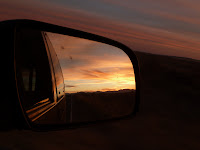
around us in a 360 degree panorama. Just check out this photo that Katie got, it gives you an idea of what we experienced, but again it is something that will just never translate. It was pure beauty in every sense of the word. After this stunning climax to the day, we began the long trek back to Utah and Park City. Megan had already gone for the night to the dog sitting house and we wasted no time getting to bed when we finally pulled in just before midnight.
No comments:
Post a Comment